Entry Points:

About Star Valley

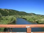
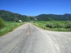
Star Valley lies to the south of the Grand Tetons along the Idaho-Wyoming border. It is bordered on the east by the beautiful Salt River Mountain Range, and on the west by a series of hills and mountains. The Idaho border passes along the western edge of the valley. The Salt River flows through the valley beginning at the south end to the north where it flows into the Palisades Reservoir. Star Valley is filled with farmland and small communities, the largest of which is Afton. The grass is usually green, and the mountains are covered in forests.

In 1858, the U.S. government built the Lander Cut-Off of the Pacific Wagon Road, a new shortcut on the Oregon Trail, which passed through Star Valley. Thousands of emigrants passed through on it up until 1912 on their way to Oregon. Star Valley was settled by Mormon pioneers who began settling here in 1880, and established all the settlements here.

A series of hills splits Star Valley into two halves a ways north of Afton. The Salt River passes through the hills in a spot called the Narrows. In spite of this apparent separation, both ends are called Star Valley.

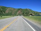
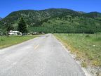
U.S. Highway 89 passes lengthwise through the valley, roughly following the route of the Lander Cut-Off. State Highway 238 passes along the west side of the valley in the southern section of the valley. Numerous other rural roads access all areas of the valley and lead into the many canyons of the mountains. The elevation at the south end of the valley is 6,800 feet, and it drops to 5,600 feet by the north end.


Street Index


a dirt road
a rest area
a turnout
Alford Way
Allred Road
Alpine Hills Drive
Appaloosa Trail
Aspen Hill Drive
Aspen Hollow Road
Aspen Lane
Aztec Drive
Barberry Way
Bateman Road
Bedford North Street
Bedford-Turnerville Road
Big Ridge Meadows Road
Big Ridge Road
Bitter Creek Road
Blue Bird Lane
Bobcat Drive
Bramble Berry Drive
Bridger Drive
Bridger Road
C-S Lane
Cameo Court
Cedar Creek Road
Cemetery Road
Chaparro Lane
Chokecherry Road
Clark Lane
CMR Drive
Commercial Park Lane
Conestoga Road
Couger Lane
Country Club Way
County Route 126A
County Route 189
Cowpoke Way
Crater Lane
Creamery Road
Crow Creek Road
Crow Creek
Cutthroat Drive
Deer Run Road
Dell Creek Road
Dew Drop Lane
Double Eagle Ranch Road
Dry Creek Road
Duffin Circle
East Etna Road
Elkhorn Drive
Ellis Lane
Etna-Forest Road
Fiddler Lane
Fisherman's Lane
Gardner Road
Griffy Lane
Grover Narrows Road
Harmony Creek Drive
Heiner-Suter Lane
Heiner-Suter Road
Hidden Lane
Hillside Loop Road
Jay-Bob Lane
Jepperson Road
KJ Lane
Lander Lane
Leavitt Road
Lever Spring Road
Liberty Lane
Lincoln Lane
Lone Star Road
Lone Tree Lane
Lost Creek Road
McCoy Road
McNeel Power Plant Road
Meadow Lane
Melody Lane
Mills Road
Moose Manor Lane
Muddy String Road
Narrows-Willow Creek Road
Noble Lane
Norbess Road
North Forest Drive
North Forty Drive
North Street
Papworth Road
Perkes Ranch Road
Perkins Road
Peterson Lane
Pheasant Trail
Pinto Lane
Piute Drive
Prater Canyon Drive
Prater Canyon Road
Private Treaty Lane
Ramblin Hills Road
Rayco Drive
Reeves-Schwab Road
Richardson Creek Drive
River Ranch Loop
Robinson Lane
Rock Farm Road
Rorke Road
Salt River
Salt River Ranch Road
Sanderson Lane
Shooting Star Drive
Smoot-Afton Road
South Street
Spring Creek Street
Star Lane
Star West Drive
State Highway 236
State Highway 238
State Highway 239
State Highway 241
State Highway 34
State Line Road
Stevens Lane
Stewart Trail
Stone Creek Lane
Strawberry Creek Road
Strawberry Creek
Sunny Meadow Court
Swimming Pool Road
Thayne-Bedford Road
The Crow Creek
The Road Home
Salt River
Tolman Lane
Trail Home
Trail Ridge Road
Troutwater Run
Twin Spruce Lane
Tyler Lane
U.S. Highway 89
Vista Drive
Waterline Road
West Hills Drive
Willow Brook Lane
Willow Creek Lane
Willow Creek
Willow Lake Drive
Yellowstone Drive

In Star Valley:

2,583 Photographs

Star Valley is in:

Services:


TERMS + CONDITIONS | COPYRIGHT 1999-2016 UNTRAVELEDROAD