Entry Points:

About Lincoln County
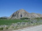
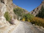
Lincoln County covers 4,069 square miles along the western border of Wyoming. Located deep in the Rocky Mountains, it is an alpine setting where valleys are 6000 feet high and mountains are 10,000 feet high. It includes sagebrush-covered deserts, forested mountain peaks and valleys of green farmland. The sedimentary soils hold fossil records of a prehistoric time when Lincoln County enjoyed a tropical climate, as can be seen at Fossil Butte National Monument.
It became a county in 1913, with it’s county seat at Kemmerer. Before that it had been a part of Uinta County. It’s early history begins with the Oregon Trail, which passed through using different routes at different times. The earlier routine followed the Bear River past Cokeville and toward Montpelier in Idaho. Later on, the Lander cut-off was built which passed through Star Valley where Afton is now located. Cokeville was the first settlement, in 1874. Star Valley was settled in 1879. Coal deposits at Kemmerer brought about it’s settlement in 1881. It now boasts the largest open pit coal mine in the world.
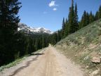
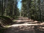
The forested areas lie in the northern part of the county, east of Star Valley. The peaks of the Salt River Range and the Wyoming Range reach up to 11,000 feet, bringing snow and rain, very important considerations in this generally dry climate.
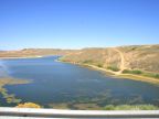
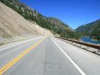
Three important rivers pass through Lincoln County: the Bear River, which flows into the Great Salt Lake, is the longest inland river in the world. The Snake River originates in Yellowstone National Park, crosses the northern tip of the county, flows westward across the great Snake River Basin of southern Idaho, and joins the Columbia River before flowing into the Pacific Ocean. The Green River passes the eastern border of the county, flowing southward into Utah, where it joins the Colorado River, passes through the Grand Canyon, and empties into the Gulf of California.
Other Lincoln Counties:
Many states include a Lincoln County. On UntraveledRoad, you can also visit Lincoln County in Idaho.