Entry Points:

About Turnerville
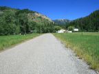
Turnerville is a small ranching town in a picturesque corner of Star Valley at the feet of the Salt River Mountains. It is secluded off the main highway, accessed by several miles of paved rural roads. Star Valley lies to the north, and hills enclose Turnerville on the east and the south. Willow Creek Canyon cuts into the mountains on the east, and Willow Creek flows out of it and westward across the valley. Turnerville is surrounded by green grasslands and the mountains are forested.
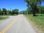
U.S. Highway 89 misses Turnerville by several miles to the west. Bedford-Turnerville Road heads northward out of Turnerville to the town of Bedford, another tiny ranching town, and from there Strawberry Creek Road leads westward to the highway. A dirt road passes through the Bridger National Forest to the south, and comes out at Grover, which is also located on Highway 89.
Turnerville is unincorporated, but the Census Bureau has its population listed as 192, at the 2010 census. The elevation is a lofty 6,448 feet. The houses in Turnerville are mostly scattered along the main road, with a few on the only cross-street, Willow Creek Canyon Road. This road quickly turns into a narrow mountain road at the east edge of town.
For More Information:
See Wikipedia’s article on Turnerville.
Street Index
|
Bedford-Turnerville Road Brookside Lane Kimballs Crossing |
Wheeler Road Willow Creek Canyon Road |