Entry Points:

About Bedford
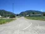
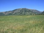
Bedford is an unincorporated community off the main roads in Star Valley in western Wyoming. The Salt River Mountains stand just east of Bedford, rising to as much as 10,000 feet in elevation, providing a beautiful backdrop to the scenery. Ranching is the primary agricultural occupation in the area, and fields of hay and grazing land surround the town. Strawberry Creek flows past a short distance to the south, lined with trees that grow along its banks.
Star Valley extends for many miles to the north and even reaches into Idaho. To the south of Bedford, it narrows down at Bedford, as a sequence of hills rises in the middle of the valley. The Salt River flows through these hills in “The Narrows”, a few miles to the west. Beyond the hills, to the south, the valley opens up again. Strawberry Creek has its sources in the mountains to the east, and flows through the hills to meet the Salt River.
U.S. Highway 89 bypasses Bedford, following the Salt River through the narrows. Strawberry Creek Road heads west out of Bedford to connect to the highway. Thayne-Bedford Road heads north out of Bedford, and loops through ranchland for several miles to reach Thayne, which is on the highway. Bedford-Turnerville road heads south to reach the community of Turnerville.
Bedford is predominantly a Mormon community, and the LDS Church is the largest building in town. Mormon pioneers settled the area in the late 1800s. The population was just 169 at the 2000 census. The elevation is 6,283 feet.
For More Information:
See Wikipedia's article on Bedford.
Street Index
|
A Street Abe Lane Astle Road B Street |
Bedford-Turnerville Road C Street First West Street Main Street |
Second West Street Strawberry Creek Road Strawberry Street |